Supplementary Features and Accessory Clouds
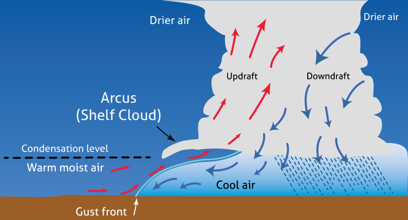
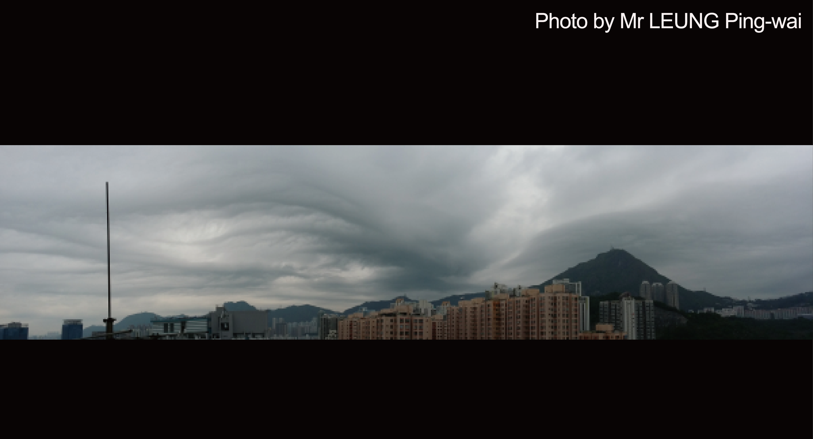
Arcus is a rare type of accessory cloud of cumulonimbus or cumulus congestus. It is grey, with horizontal roll or wedge shaped form, just like a shelf supporting a storm.
Arcus normally develops when cool air from strong downdraft (namely the gust front) associated with a mature cumulonimbus sinks rapidly to the ground. This forces the surrounding warm moist air to uplift along the gust front and then cool and condense, forming arcus cloud at the bottom of the cumulonimbus and in the direction of cloud movement. The edging of extensive arcus clouds usually portends an approaching severe storm. Arcus sometimes only lasts for a very short period of time.
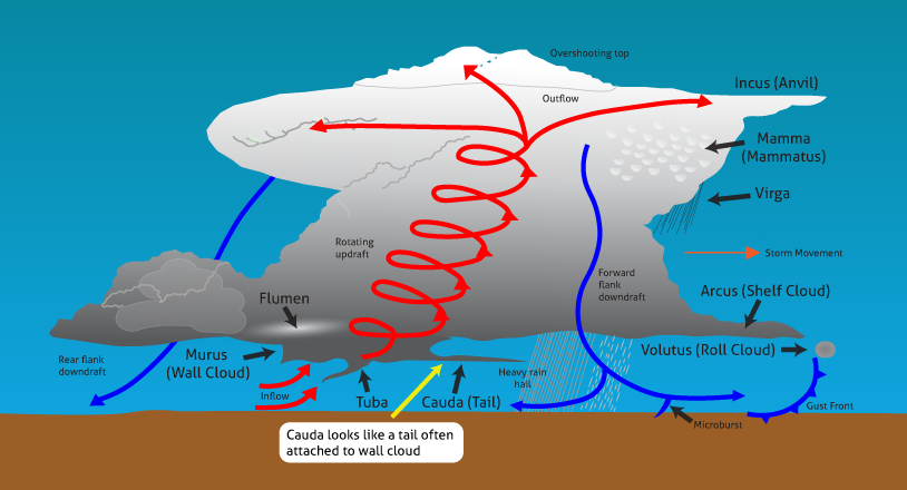
Cauda is a new supplementary feature included in the 2017 updated edition of the International Cloud Atlas of the World Meteorological Organization.
Cauda is a horizontal, tail-shaped cloud (not a funnel) at low levels extending from the main precipitation region of a supercell cumulonimbus to the murus (wall cloud). It is typically attached to the wall cloud, and the bases of both are typically at the same height.
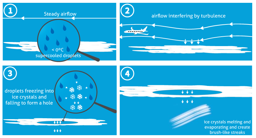
Cavum is a new supplementary feature included in the 2017 edition of the International Cloud Atlas of the World Meteorological Organization.
Cavum is a well-defined generally circular hole in a thin layer of supercooled water droplet cloud. Supercooled water droplets form when water cannot freeze even when temperature is lower than the freezing point as there are not enough condensation nuclei in the air. If there are interferences such as turbulence caused by aircrafts, supercooled water droplets may start freezing into ice crystals, triggering a chain effect with surrounding water droplets freezing onto the ice crystal. With increasing weight, the ice crystal will then fall to form a hole. The falling ice crystals will melt and evaporate, creating typical brush-like streaks (virga or wisps of cirrus). Cavum is also commonly known as “fallstreak hole”.
Cavum is typically a circular feature when viewed from directly beneath, but may appear oval shaped when viewed from a distance. When resulting directly from the interaction of an aircraft with the cloud, the hole is generally liner in shape in the form of a dissipation trial (distrail). Cavum occurs in altocumulus or cirrocumulus, rarely in stratocumulus.
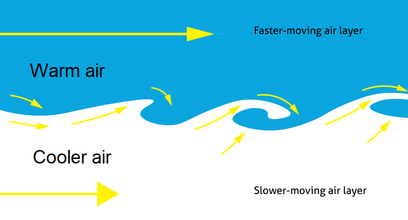
Fluctus is a new supplementary feature included in the 2017 updated edition of the International Cloud Atlas of the World Meteorological Organization.
Fluctus is a relatively short-lived wave formation, usually on the top surface of the cloud, in the form of curls or breaking waves (Kelvin-Helmholtz waves). It looks like huge waves rolling across the sky. Fluctus (Kelvin-Helmoholtz Billow) forms at the boundary between two layers of air with different temperatures and speeds but in the same direction of movement. The air layer with slower speed will cut into the layer with higher speed, causing the latter to be distorted into a wavy shape. This phenomenon is also called “Kelvin-Helmholtz instability”. Fluctus occurs mostly with cirrus, altocumulus, stratocumulus or stratus, occasionally with cumulus.
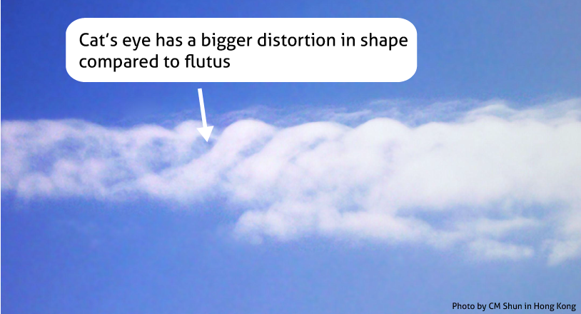
“Cat’s Eye” cloud just looks like the eyes of a cat. Its formation mechanism is the same as fluctus but with even stronger shearing flows between the two layers of air, thus causing stronger distortion of the shape.
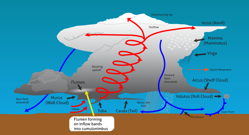
Flumen are new accessary clouds included in the 2017 updated edition of the International Cloud Atlas of the World Meteorological Organization.
Flumen are bands of low clouds associated with a supercell severe convective storm (or cumulonimbus), arranged parallel to the low-level winds. These accessory clouds form on an inflow band into a supercell storm and the cloud elements move towards the updraft into the supercell. The flumen are not attached to murus (wall cloud) and their cloud base is higher than that of wall cloud.
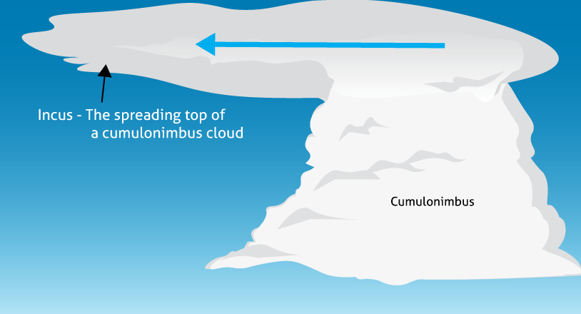
Incus is the spreading top of a cumulonimbus cloud in the shape of an anvil. It is distant from the main body of the thunderstorm’s heavy rain region. Anvil is so high that rain originating from it will normally evaporate before reaching the ground. However, lightning from anvil is able to travel through dry air and reach the ground.
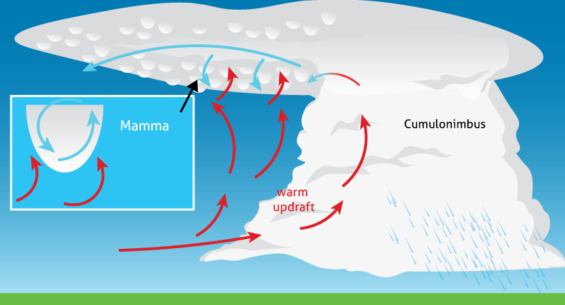
Mamma may occur when the atmosphere is unstable. It can be found in different cloud genera. The most striking example is the one occurs at the base of anvil that spread on the top of well-developed cumulonimbus clouds. The punch-like structure of mamma develops on the under surface of a cloud when the updraft of moist air near anvil loses its rising momentum, and by adding its own weight produces strong downdraft and sinks to the dry air beneath. Mamma occurs mostly with stratocumulus or cumulonimbus. It will also occur with cirrus, cirrocumulus, altocumulus or altostratus.
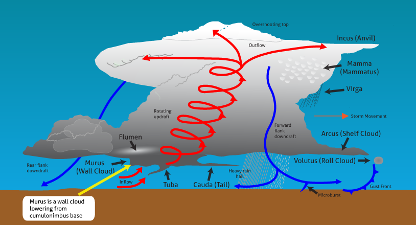
Murus is a new supplementary feature included in the 2017 updated edition of the International Cloud Atlas of the World Meteorological Organization.
Murus is localized and persistent, and is often an abrupt lowering of cloud from the base of a cumulonimbus. It is usually associated with a supercell or severe multi-cell storm, and it typically develops in the rain-free portion of a cumulonimbus, a region of strong updraft. Murus showing significant rotation and vertical motion may result in the formation of tuba (spouts). It is also commonly known as “wall cloud”.
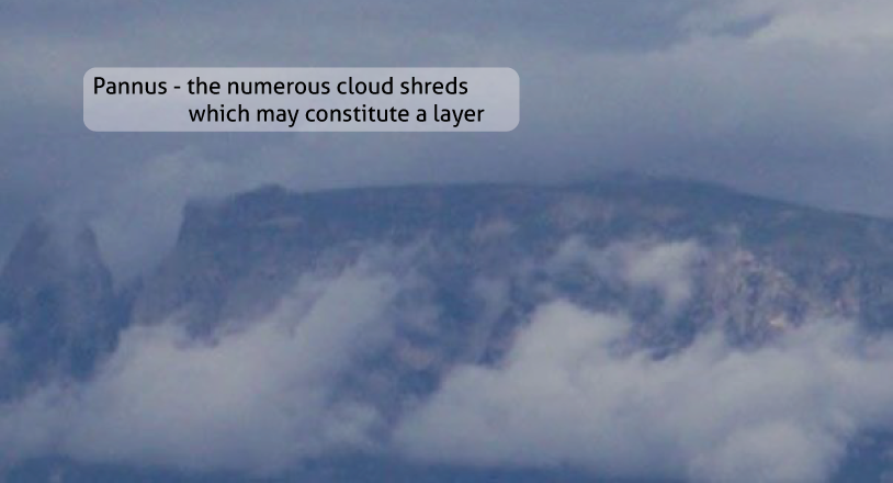
Pannus refers to numerous cloud ragged shreds which may sometimes constitute a layer. It may be situated below the main cloud, or attached to it. This accessory cloud occurs mostly with altostratus, nimbostratus, cumulus or cumulonimbus.
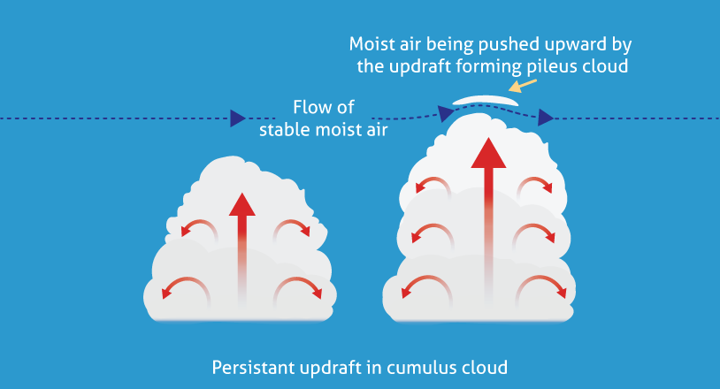
Pileus is a smooth cap-cloud that forms above the cloud top of cumulus or cumulonimbus. When a stable and moist airstream flowing above the cloud top is forced to ascend due to rapidly developing cumulus or cumulonimbus in the vertical, the air will condense after cooling, forming a thin cap aloft and mimicking a head band on the top of cumulus or cumulonimbus.
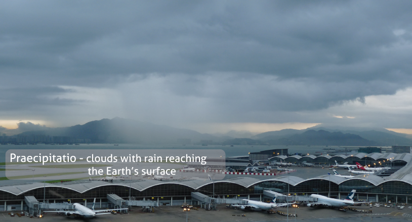
Praecipitatio refers to a cloud with rain reaching the Earth’s surface. It mostly occurs with altostratus, nimbostratus, stratocumulus, stratus, cumulus or cumulonimbus.
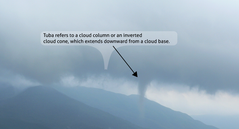
Tuba refers to a cloud column or an inverted cloud cone, which extends downward from a cloud base, indicating that there is an intense vortex. It mainly occurs with cumulonimbus, relatively less with cumulus.
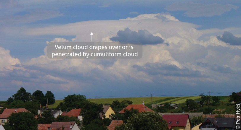
Velum forms by cumulus growing through a thin sheet of cloud, an accessary cloud close to or attached to the upper part of a cumulus or cumulonimbus. It usually has great horizontal extent.
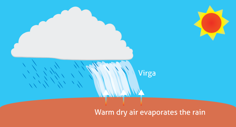
Virga develops as vertical or inclined trails of precipitation (fallstreaks) attached to the under surface of a cloud, which has evaporated before reaching the Earth’s surface. It occurs mostly with stratocumulus, cumulus, cumulonimbus, altostratus, altocumulus, nimbostratus or cirrocumulus.
