Low Clouds
Low clouds appear closest to the ground among the three cloud levels. In tropical region like Hong Kong, the cloud base usually ranges between surface and 2,000 metres (around 6,500 feet). Stratus, stratocumulus, cumulus and cumulonimbus fall into the category of low clouds.

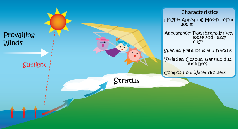
Stratus is generally grey in appearance with a fairly uniform base, which may give drizzle, snow or snow grains. It is usually composed of small water droplets. Sometimes stratus appears in the form of ragged patches.
Stratus may develop from stratocumulus when the cloud base of the latter becomes lower or loses support from orographic uplifting. The lifting of fog due to warming or an increase in wind speed may also bring about the formation of stratus.
According to the “International Cloud Atlas” published by the World Meteorological Organization (WMO), stratus contains the following types:
Cloud species: nebulosus, fractus;
Cloud varieties: opacus, translucidus, undulates;
Supplementary features and accessory clouds: praecipitatio.

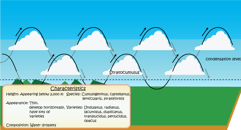
The appearance of stratocumulus is often grey or whitish in colour and in the form of a block, a sheet or a layer normally with some dark parts. Stratocumulus can be made up of tessellations, rounded mass or roll shaped clouds (except for virga). Most of the regularly arranged small cloud blocks have an apparent width of more than 5 degrees*.
Stratocumulus may sometimes be confused with altocumulus. If most of the regularly arranged small cloud blocks are at an angle of more than 30 degrees above the horizon, and have an apparent width of more than 5 degrees, then it is stratocumulus. Generally stratocumulus is composed of water droplets. If the cloud layer is not thick, sometimes corona or irisation can be seen.
According to the “International Cloud Atlas” published by the WMO, stratocumulus contains the following types:
Cloud species: cumulogenitus, castellanus, lenticularis, stratiformis;
Cloud varieties: translucidus, perlucidus, undulatus, opacus, radiatus, lacunosus, duplicatus;
Supplementary features and accessory clouds: mamma, virga, praecipitatio.
* If a centimetre rule is held at arm’s length, a finger span of one centimetre is approximated to a visual width of 1 degree.
。

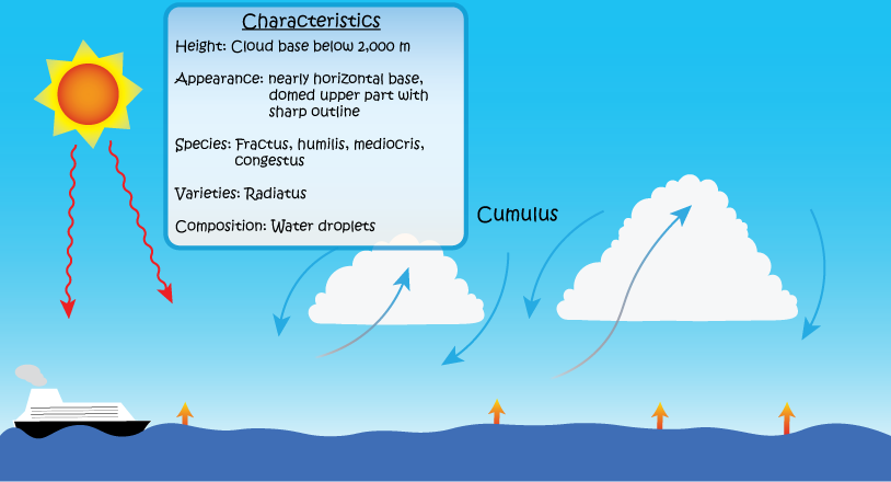
Cumulus usually occurs in fine weather. It looks puffy, cotton-like or fluffy with generally dense and sharp outlines. It develops vertically in the form of a rising mound dome or tower, of which the bulging upper part often resembles a cauliflower. The sunlit part of the cloud is mostly white, but its base is relatively dark and flat. Sometimes cumulus appears patchy.
Although cumulus is an individual cloud, cumulus clouds may appear to have merged together when viewed at a distance. Owing to its generally great vertical extent, cumulus may spread out and form stratocumulus or altocumulus cumulogenitus, or even penetrate the existing layers of stratocumulus or altocumulus. Provided that the cumuliform clouds remain detached from one another, they are still classified as cumulus. If a precipitating cumulus is located directly above an observer, its characteristics may be difficult to discern. It may also be easily confused with altostratus or nimbostratus.
According to the “International Cloud Atlas” published by the WMO, cumulus contains the following types:
Species: fractus, humilis, mediocris, congestus;
Varieties: radiatus;
Supplementary features and accessory clouds: pileus.

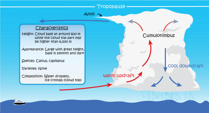
Cumulonimbus looks heavy and dense, with considerable vertical extent, in the form of a mountain or a huge tower. Part of its upper portion is smooth, a small part of it is fibrous, striated, or flat. This part often spreads out in the shape of an anvil or a vast plume. The base of a cumulonimbus is often dark, accompanied with scattered clouds, and sometimes precipitating virga.
Cumulonimbus cloud normally develops from large cumulus. It can also develop from stratocumulus castellanus or altocumulus castellanus. When cumulonimbus clouds cover a large extent in the sky, their cloud base may appear as nimbostratus. The characteristics of precipitation may help identify the presence of cumulonimbus. Cumulonimbus brings showers, which are often relatively heavy but not too persistent. If hail, thunder or lightning is observed, then the associated cloud is certainly cumulonimbus.
The evolution of a cloud also aids to identify its genera. The change in the appearance of a large cumulus with domed tops and clear-cut outline (produced by water droplets) to one with a relatively soft fibrous outline (produced by ice crystals) on its top marks the development of a cumulus to a cumulonimbus cloud.
Cumulonimbus can be described as a ‘cloud factory’ of genera. It can produce many other types by extending its top, for example thick and small patches of cirrus spissatus, altocumulus, altostratus or stratocumulus. An anvil usually appears on its top. If wind increases with height, the anvil will disperse downwind in the shape of a half anvil or a vast plume.
According to the “International Cloud Atlas” published by the WMO, cumulonimbus contains the following types:
Species: calvus, capillatus;
Varieties: None;
Supplementary features and accessory clouds: incus, mamma, virga, praecipitatio, arcus, tuba, pileus, velum, pannus.