Weather Radar Image
The image shows the rainfall rate at a height of 3 km above the mean sea-level.


-
Radar Image
GalleryThe radar image gallery contains radar pictures of severe weather including tropical cyclones, rainstorms, hailstorms and thunderstorms. There are also pictures containing artefacts caused by special conditions in the atmosphere and also the way radar operates. These pictures are included in the gallery to remind readers that radar imageries should be interpreted with caution.
-
 Gust Front
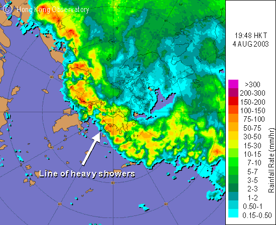
4 August 2003
The radar image shows a line of heavy showers lying SE-NW over Hong Kong, and gusts of up to 70 km/h were recorded at Chek Lap Kok that evening. The foremost edge of gusts is known as the gust front.
 Winter Rain
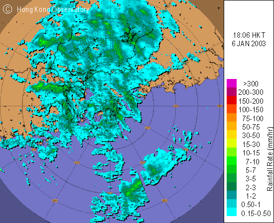
6 January 2003
This is a typical example of winter rain brought about by intense cold surges. It rained extensively and continuously over Guangdong that day, and the temperature in Hong Kong dropped to 8.8 degrees with a total rainfall of 16.5 mm recorded.
 Squall Line
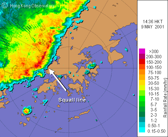
9 May 2001
The image shows the approach of an intense squall line associated with an active trough of low pressure. Embedded in this line were squally thunderstorms that brought heavy rain to Hong Kong that afternoon. In Kwai Chung, about 50 containers were blown over by gusts.
 Hailstorm
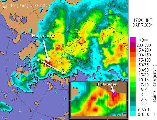
9 April 2001
The radar image captures an active hailstorm near Tsing Yi. The subsequent southeastward movement of the hailstorm brought hailstones of diameter up to 2.5 cm to most parts of Kowloon later that afternoon.
-
Typhoon
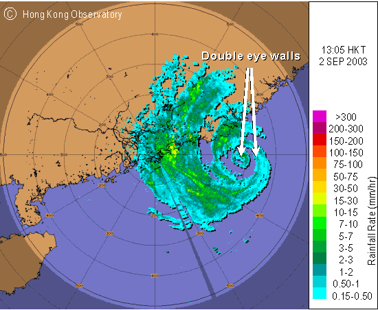
Dujuan2 September 2003
The image reveals the double eye-wall structure of Dujuan as she approached the eastern coast of Guangdong. The diameters of the inner and outer eyes were about 20km and 100km respectively.
Severe Tropical Storm
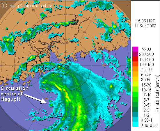
Hagupit11 September 2002
The image depicts Hagupit's asymmetric distribution of rain bands, which were mainly located on the eastern and northern sides of the storm. This Severe Tropical Storm came rather close, with its centre only about 150 km to the south-southwest of Hong Kong.
 Yutu
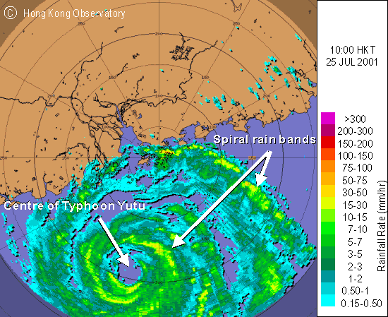
Yutu25 July 2001
The circular eye of Yutu could clearly be seen in the image at about 200 km to the south-southwest of Hong Kong, and the outermost spiral rainband was affecting the territory at the time.
 Vicente
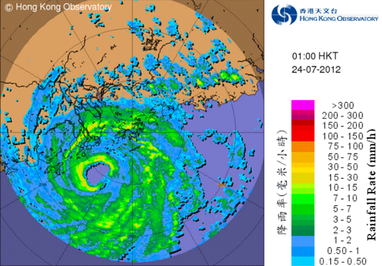
24 July 2012
The centre of Vicente is shown to be at about 100 km to the southwest of the Hong Kong Observatory, with the associated rainbands sweeping across Hong Kong and the coast of Guangdong.
-
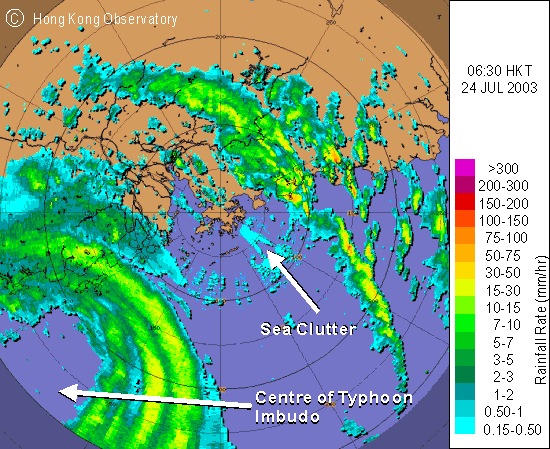 Sea Clutter
24 July 2003
The radar image shows some relatively weak but uniform echoes over the surrounding waters of Hong Kong. This kind of spurious echoes is caused by reflections off rough sea surfaces under gale-force winds.
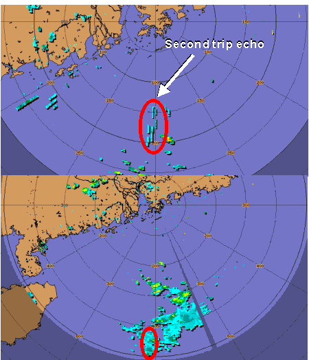 Second Trip Echo
19 June 2003
The strips in the upper figure are second trip echoes caused by rain at a distance beyond the range of that particular scan. The rain responsible is captured in the lower figure by another scan with a longer range at 400 kilometres to the south.
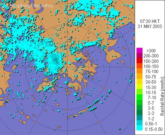 Anomalous Propagation
31 May 2003
Under certain weather conditions (e.g. when the air is stable), the microwave sent from the radar which would otherwise travel in a straight line might bend towards the ground. The reflected microwave would give the radar a false impression of rain as in the image on the left.
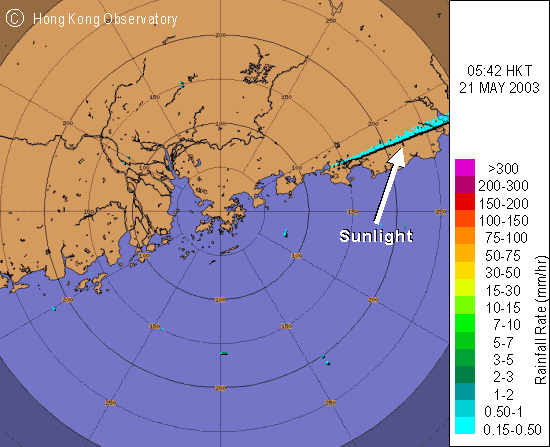 Sunlight
21 May 2003
Sunlight contains microwave that matches the operating frequency of the radar. Particularly at sunrise and sunset, the radar may capture the microwave from the sun and mistake it for its own. The radar echo thus received would be in the form of a radial beam.


