Weather Forecast
The "9-day Weather Forecast" provides a general overview of the weather in the coming week.
-
Weather WarningsTropical Cyclones

STANDBY
A tropical cyclone is centred within about 800 kilometres (km) of Hong Kong and may affect the territory.

STRONG WIND
Strong wind is expected or blowing generally in Hong Kong near sea level, with a sustanined speed of 41-62 kilometers per hour (km/h), and gusts which may exceed 110km/h, and the wind condition is expected to persist.
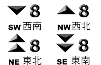
GALE OR STORM
Gale or storm force wind is expected or blowing generally in Hong Kong near sea level, with a sustained wind speed of 63-117 km/h from the quarter indicated and gusts which may exceed 180km/h, and the wind condition is expected to persist.

INCREASING GALE OR STORM
Gale or storm force wind is increasing or expected to increase significantly in strength.

HURRICANE
Hurricane force wind is expected or blowing with sustained speed reaching upwards from 118km/h and gusts that may exceed 220km/h.
Knowing signals = Enough?
Weather in different parts of Hong Kong cannot simply be inferred from the signal issued, so just knowing what signal is issued is NOT ENOUGH. You should take note of the latest tropical cyclone broadcasts on radio and TV, announcements on the Hong Kong Observatory's Internet website (https://www.hko.gov.hk/ and https://www.weather.gov.hk/), and information given through the Dial-a-Weather system (Tel. No.: 1878 200), to decide on the precautionary actions to take.Classification of
Tropical CyclonesTropical DepressionTropical StormSevere Tropical StormTyphoonSevere TyphoonSuper TyphoonMaximum sustained winds
near Centre (km/h)62 or below63-8788-117118-149150-184185 or more -
Weather WarningsRainstorm
The Rainy Season
The rainy season in Hong Kong is normally between April and September. Rain could be particularly heavy and persistent during May and June, causing severe traffic disruptions and on occasions major floods and landslips resulting in casualties.
The Use of
Rainstorm Warning SystemThe rainstorm warning system is designed to alert the public about the occurrence of heavy rain that is likely to bring about major disruptions, and to ensure a state of readiness within the essential services to deal with emergencies. It is independent of other severe weather warnings, such as the tropical cyclone warning and landslip warning, which will be issued separately where necessary.
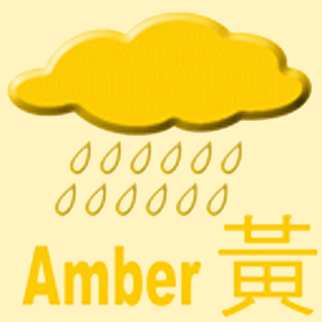 AMBER RAINSTORM SIGNAL
Heavy rain has fallen or is expected to fall generally over Hong Kong, exceeding 30 millimetres in an hour, and is likely to continue.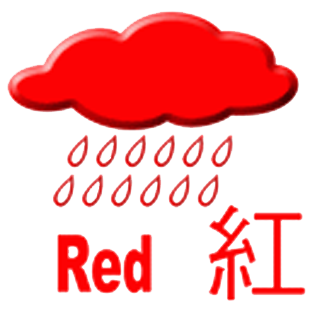 RED RAINSTORM SIGNAL
Heavy rain has fallen or is expected to fall generally over Hong Kong, exceeding 50 millimetres in an hour, and is likely to continue.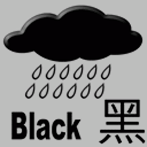 BLACK RAINSTORM SIGNAL
Heavy rain has fallen or is expected to fall generally over Hong Kong, exceeding 70 millimetres in an hour, and is likely to continue. -
Weather WarningsMore Warnings
 As the development of thunderstorms can be fairly rapid and localised, this warning is to draw particular attention to thunderstorms that are about to or are taking place, whether previously expected or not.
 This warning is issued whenever ground frost is expected to occur on high ground or inland in the New Territories.
 A Special Announcement on Flooding in the northern New Territories is issued whenever flooding induced by heavy rain is expected to occur or is occurring in the low-lying plains of the northern New Territories.
 A fire danger warning is issued whenever the relative humidity of the atmosphere falls below certain criteria and the vegetation is dry. A yellow fire danger warning indicates that the fire risk is high, while a red fire danger warning indicates that the fire risk is extreme.
 A landslip warning is issued by the Hong Kong Observatory in conjunction with the Geotechnical Engineering Office when persistent heavy rainfall results in a high risk of numerous landslips occuring.
 Hong Kong experiences both hot and cold seasons, and the Observatory maintains a close watch on local temperature changes. Warnings are issued whenever Hong Kong is threatened by cold or very hot weather, so to alert members of the public of the danger of low body temperature and the risk of heatstroke respectively.
 The Strong Monsoon Signal is issued when winds associated with the summer or winter monsoon are blowing in excess of or are expected to exceed 40 kilometres per hour near sea level anywhere in Hong Kong.
 This warning is issued when a severe earthquake is expected to generate a tsunami that would reach Hong Kong within 3 hours, and the height of this tsunami may exceed 0.5 metre above the normal tide level.


